Winkwentowin is a key neighborhood for the city, presenting a rare (once in a lifetime,...
Winkwentowin is a key neighborhood for the city, presenting a rare (once in a lifetime, realistically) opportunity to implement strategies that align with the city's goals and set a precedent for future renewal projects. If you have not seen the proposed designs and vision for the neighborhood, take a look here, though this post will break that document down and compare the designs on a location-by-location basis.
This post will detail some specific suggestions for improvement to the proposed designs with a focus on the smaller proposals for the neighbourhood The larger, more visionary proposals are broken down here.
These suggestions take into account the following:
- Current City plans and goals
- The lived experiences of cyclists in Edmonton
- Empirical evidence
- The fiscal sustainability of the City, and the impact of this project (and others) on future tax increases
These considerations are detailed in a separate blog post, which also lays out why we think this renewal project is so important. You can also see our comparison of the larger proposals in this project here.
Project Overview
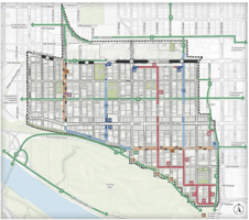
Below you will see a map of the project area. The locations highlighted in green are the locations with design proposals that are currently taking feedback. We understand that designs for some locations in the project area will not be subject to public engagement as the changes will be inline with current neighborhood renewal and complete street guidelines. Other locations may be subject to the engagement process at a later time.
The full design package is available here.

Note:
Some deigns have point of view renders. When these are used, the deign will have an orange cone showing the direction and field of view of the street level rendering.
Design Details
98 Ave from 111 Street to the alley east of 110 Street
Option 1 includes a "local street bikeway" whereas Option 2 includes a shared pathway. Both include increased public space.
|
Option One: Local Street 'Bikeway' and (motor vehicle) traffic calming |
Option Two: Shared Pathway, increased public space |
|
The 'Local street bikeway' is described as: A street where people who bike and people who drive share the street without separated bike infrastructure. The bikeway typically includes pavement markings and signage. It has been noted that painted lines are not infrastructure, and often worse than none at all. The proposed treatment is unsafe and completely inappropriate in all applications. (The 'Local Bikeway' in option 1 does not provide safe, separated infrastructure for people on bicycles. A grade-separated, multi-use path is the minimum acceptable for this connection. Because 98 Avenue connects to the 'Railtown' multi-use path as well as an LRT Station this corridor should prioritize pedestrian and bicycle traffic.) This option does a better job maintaining the current trees, though both options should consider adding additional trees to:
|
The shared pathway at 110 Street is offset from a roadway apron and intersection, placing pathway users at increased risk from motorists failing to stop or yield once they have entered the intersection. Additionally, the shared pathway stops at the alleyway, failing to safely connect with the 'Ribbon of Steel' pathway and leaving people vulnerable to motorists turning to and from the alleyways which only provide access to adjacent properties and do not require such ample space given the presumed low count of motor vehicle movements. One suggested improvement is to continue the pathway straight, and continuously to connect with the Ribbon of Steel. The remaining 3 parking spots on the south side of 98 avenue east of 110 street would be removed to accommodate this alignment and public space would be improved on the north pathway (more consideration for people using the shared use path). Also consider closing the alley on the North side of 98 avenue East of 110 street to further reduce interaction and potential conflict points while improving life for the residents adjacent by discouraging high volumes of through traffic (assuming there is adequate alternative access) |
|
|
|
A proper "Local Street Bikeway" is a safe and low-cost way of supporting on street cycling. However, for these to be effective, it is vital that significant traffic calming is done to prevent any through-cutting on the route of the bikeway. To accomplish this, the City should consider removing on street parking along the bikeway and ensure that drives cannot use the route as an alternative to local collectors or arterial roads when their trip does not start or end in Wîhkwêntôwin. Failing to do this leaves the neighbourhood with streets that are effectively "Shared Streets" which have been demonstrated to be both confusing & frustrating for drivers while also being unsafe for cyclists.
In general, fully separated and protected bike infrastructure is preferred. We know that newer or less confident riders are more likely to use bike lanes that are properly separated and removed from traffic. The proposed designs could be improved by ensuring there is enough space for different types of users, and we would prefer to see more tree coverage for the improved shade.
Whatever gets built must accommodate growing demand and diverse user types, including fast and slow cyclists, e-bikes, cargo bikes, scooters, wheelchairs, pedestrians, people walking dogs or with children, and other electronic devices which are capable of very high speeds.
99 Ave from 110 Street to 114 Street
Option 1 involves some minor traffic calming at 114 Street and 99 Ave, as well as the addition of a mini-roundabout at 113 Street:

This design includes some unusual traffic calming, including random angled medians which are sure to confuse drivers and lead to conflicts. In the winter, this will likely be more dangerous for all users. Lane width narrowing, continuous sidewalks, and daylighting at intersections can all provide more effective traffic calming without the likely negative unintended consequences of unfamiliar roadway design.

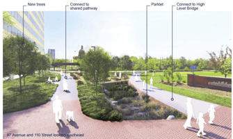
Option 2 proposes no changes to the existing infrastructure between 114 Street and 112 Street, then adding a parklet at 112 Street and some minor traffic calming between 111 Street and 110 Street:

We love the min-roundabout and the parklet. Given the volume of traffic in this area, it would be ideal to do both, or to improve the intersection at 111 Street with curb extensions on both sides of the avenue, while also making 99 Ave one-way to further reduce traffic volume.
Continuous sidewalks/traffic tables are great traffic calming measures and should be considered table stakes in a busy neighbourhood like Wîhkwêntôwin. In particular, the roundabout should include a traffic table to provide additional calming for vehicles while providing continuous crossings for pedestrians and users with mobility needs, like parents pushing strollers or wheelchair users.
The shared pathway through the proposed parklet has the benefit of providing adequate space for all users, with sidewalks continuing through the park separate from the active transportation infrastructure.

Finally, the entry to the parklet would need to be bollard protected to ensure vehicle traffic does not unintentionally try to use the space.

In our opinion, a better design would be to integrate the best of each of the above, with additional traffic calming, and adding continuous sidewalks/traffic tables to all intersections:
This section should be augmented with fully protected bike lanes on 100Ave, connected to the rest of the downtown bike network. No designs for 100 Ave have been released at this time, but we understand that this is reasonable to expect as part of the Bike Plan.
102 Ave from 121 Street to 124 Street
Two options have been proposed here as well, one that maintains two-way traffic without offering much in the way of traffic calming, and the other which would reduce the avenue to one-way traffic (travelling westbound) with additional traffic calming and a shared use path.
Option One:
Option Two:
 |
 |
If the only choice is to adopt one of the proposed options, then the clear preference here is option 2 which increases public space and improves the public realm by lessening the disruption caused by automobiles to people living, working, or visiting Wîhkwêntôwin. Cars have exacerbated social inequities and damaged ecosystems in every global region, including in remote car-free places. While some people benefit from automobility, nearly everyone—whether or not they drive—is harmed by it. For instance in 2022 motorists killed or injured 129,635 people in Canada including, on average, one child under 15 every day.
When project staff were asked why Option 2 is only feasible with the almost complete closure of 121 Street the response was 'motor vehicle traffic circulation'. It seems that the project team are still prioritizing motorists and automobiles overall when the overwhelming desire from residents and businesses has been to improve the human experience by reducing motor vehicle traffic in the project area.
Though both options increase the public space available, neither provide usable public space beyond the sidewalks and active transportation lanes. By building these huge concrete spaces with inadequate tree cover adjacent to a busy traffic corridor, these public spaces are not exactly inviting. In the summer, these will be hotspots, and in the winter they will almost certainly not be shovelled, making them useful for the shoulder seasons at best. Given that this is the current location of the 124 Street Farmer's Market, this design should be improved to provide adequate space for the market that wouldn't require sidewalk or active transportation network closures. Better yet, 123 Street would be closed and turned into a public space that is designed for activities like farmer's markets and other activation.
Ideally, this section of road would be closed to vehicle traffic entirely, with the use of retractable bollards to allow bus service and DATS to continue through the area. This would provide adequate space to improve the public space available, without needing to remove tress (as proposed in option 2). It appears that all parking is accessible via the alleys, so closure of 102 Ave does not reduce parking availability in any meaningful way (the major impact is the removal of ~15 parking spaces on 102 Ave).
Conclusion
The proposed designs are a significant improvement over the existing infrastructure in the neighbourhood, and we applaud the hard work of the project team. However, it cannot be overstated that this is a key neighbourhood in the City, with several existing issues that must be solved through this renewal process. Through-cutting is a major issue in this area, with many people trying to shortcut through Wîhkwêntôwin rather than using the arterial roads that are available within a couple of blocks in any direction. Additionally, there are already significant issues with traffic in the area including non-compliance of various traffic laws, especially at stop signs and crosswalks where drivers fail to safely yield to pedestrians, and at every intersection where bike lanes are present where drivers consistently have 'near miss' incidents with cyclists.
Traffic circulation has been listed as a priority. Certainly, access to private parking must be maintained, and it must be possible to get to/from every private residence within the area, however, beyond that, driving in the area should be as difficult and indirect as possible. Not only would this realize the City's Vision Zero goals by prioritizing the safety of vulnerable roadway users above the slightest inconvenience to drivers, but these measures would support several of the City's other goals, as we have detailed here.
We are building a neighbourhood for thirty years from now, not thirty years ago, this is our last chance to get it right for another generation. Over that time, Wihkwentowin is expected to double in size by ~2050 and people are not moving here because of parking; parking and auto-centricity are harmful to the things that do bring families and diverse communities to the area - walkability, bikeability, and a genuinely enjoyable human experience. Though finances are tight at City Hall, this is one of few neighbourhoods that generates more taxes than are required to service the area. If we want that to continue, we must invest in the area to ensure this is a neighbourhood that people want to live in or start and grow their businesses within. In fact, this area is nationally ranked (#3 Canada-wide) for it's livability, and not once is free parking or short-cutting to get to MacEwan or downtown listed as a key consideration.