-3.png?height=200&name=YEG%20Bike%20(3)-3.png)
Edmonton is now ten years into Vision Zero. Yet instead of driving traffic deaths toward zero,...
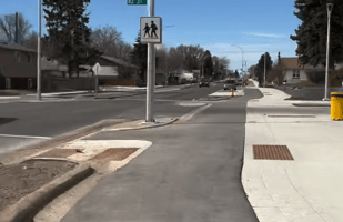
Wîhkwêntôwin (Oliver) is not a neighbourhood struggling to become vibrant. It already is.
It is one of the most densely populated neighbourhoods in Edmonton, one of the most walkable, and a place where a large share of daily trips already happen without a car. People walk, bike, roll, take transit, meet friends, shop locally, and use public space every day — not because they have to, but because the neighbourhood already works.
That’s what makes the final draft of the Wîhkwêntôwin Neighbourhood Renewal designs so important — and so frustrating.
This project will shape how people move through and experience the neighbourhood for the next 30–50 years. It’s a once-in-a-generation chance to lock in safety, accessibility, and vibrancy. When designs rely on speed management instead of physical protection, the people most harmed are those with the least margin for error: seniors, children, and people with mobility constraints. Some parts of the design get this exactly right. Too many others step back, prioritizing parking preservation and vehicle shortcutting over the people who already live, work, and spend time here.
This project can still be fixed. But only if we’re honest about what went wrong — and why it matters.
TL;DR
- Wîhkwêntôwin already works — the design should build on that success, not water it down.
- Too much of the final plan prioritizes parking and vehicle shortcutting over safety.
- Shared-use paths and “local street bikeways” won’t function year-round and do not meet Vision Zero standards, especially for people with disabilities or mobility constraints.
- Inconsistent crossings, winter-only gaps, and shortcutting traffic disproportionately harm seniors, children, and people with disabilities — not just cyclists.
- Preserving subsidized on-street parking is fiscally irresponsible in a dense, transit-rich neighbourhood and undermines City Plan goals.
- The City should restore earlier designs that reduced shortcutting, build real bike infrastructure (Snow and Ice Control) SNIC can clear, and lean into people-first spaces.
- This project can still be fixed — but only if the City chooses safety, equity, and long-term value over short-term convenience.
CTA
Want to help influence this? Here's what you can do:
- Share you feedback! We have a lot of info below you can use as a starting point.
- Attend the in-person engagement sessions on January 29 and 31:
-
Date: Thursday, January 29
Time: 5:30 - 8pm
Location: Holy Child School
9844–110 Street NW (110 Street entrance)Please note: The room where the event is being held is fully accessible, but the Holy Child School bathrooms are not accessible.
- Date: Saturday, January 31, 2026
Time: 10:30am to 1pm
Location: Wîhkwêntôwin ᐄᐧᐦᑫᐧᐣᑑᐃᐧᐣ School (formerly Oliver School)
10227 - 118 Street NW (117 Street entrance)
-
- Fill out the project survey from Thursday, January 15 to Sunday, February 8, 2026
- Attend the in-person engagement sessions on January 29 and 31:
- Phone or email the councillor for the area, Anne Stevenson, and ask that the City:
- Build only safe infrastructure, in alignment with City Plan, Vision Zero, and the Bike Plan.
- Re-instate the designs from previous iterations that reduced short-cutting and prioritized people who live and visit the area.
- Think bigger! This is an opportunity to lean into the vibrancy of an area that already works. The City wants downtown to be thriving and vibrant, but mega projects like O-day'min Park are expensive and rare. For a fraction of that cost, the project team could bring something just as good, supporting businsses, residents, and people doing the things that the City needs more people to do in order to achieve City Plan goals.
Why This Matters
Wîhkwêntôwin is exactly the kind of neighbourhood Edmonton says it wants more of.
It is dense, centrally located, well served by transit, and already supports a high share of trips by walking, rolling, and cycling. City Plan identifies areas like this as Priority Growth Areas — places where people-first design should lead, not follow.
In a redeveloping area, the City’s own standard should be infrastructure that is Always Available, All Ages and Abilities, and maintained year-round. That standard matters here because this project is not just renewing pavement. It is deciding whether the City’s long-term policies actually show up on the ground.
Vision Zero commits Edmonton to eliminating serious injuries and fatalities by designing streets that prevent crashes, not merely respond to them. The Bike Plan calls for connected, comfortable routes that people of all ages and abilities can use. Winter design policies recognize a simple reality: in Edmonton, infrastructure that does not function in winter is not reliable infrastructure.
This project also connects directly to one of the most important active transportation corridors in the city: the High Level Bridge. It is one of Edmonton’s busiest walking and cycling routes, year-round. Feeding unsafe, inconsistent, or winter-unreliable infrastructure into that corridor undermines not just this neighbourhood, but the broader network it serves.
Neighbourhood Renewal projects shape streets for decades. In a place that already works, “good enough” is not neutral. This thinking locks in missed opportunities, avoidable risk, and future retrofit costs. Getting this right now is far cheaper, safer, and more equitable than fixing it later.
That’s what makes the January 2026 draft design for Neighbourhood Renewal so frustrating. After years of engagement and multiple design phases, too many of the strongest ideas were diluted or dropped — replaced by compromises that prioritize parking supply and vehicle shortcutting over safety, clarity, and long-term success.
This project still has time to get back on track. But only if we’re honest about what’s missing.
The Project Vision Was Clear — The Final Design Isn’t Aligned
Earlier design materials laid out a strong vision:
-
Walking, rolling, and biking should be safe and convenient for all ages and abilities
-
Streets should support year-round use
-
Active transportation should connect people to destinations, transit, and the river valley
-
Design should reflect how the neighbourhood actually works today — and where it’s headed
That vision improved over the course of engagements, but in the final draft, it’s often undermined by on-the-ground decisions that send a different message:
cars first, safety later, and bikes if there’s leftover space.
We want to be very clear here. Not all areas of this design fail to meet this vision. Many areas are fine, much of the designs could be a lot better, and what's good is actually really good.
North of 100 Ave, most of the designs are great. 112 Street north of 102 Ave is an excellent design. 103A Ave is an excellent design. The closure on 97 Ave between the High Level Bridge and Ezio Farone Park is excellent.
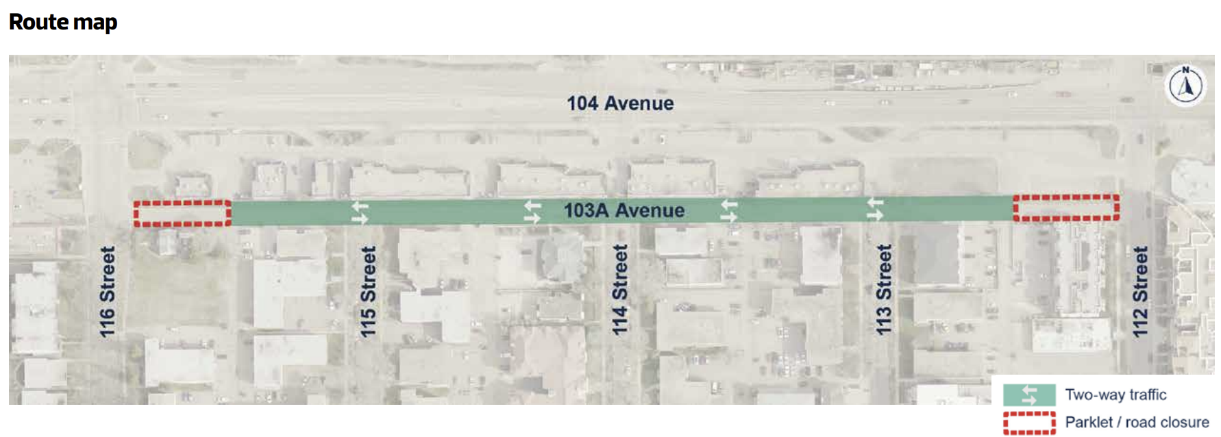
103A Ave is an excellent design that connects residents to the businesses and LRT
Some areas fail to be visionary. 121 Street and 102 Ave have so much potential to be amazing people first spaces but the team has failed to realize that potential, even when better alternatives wouldn't negatively affect drivers.
Other areas fail to meet even reasonable minimum standards. Local Street Bikeways that are just better than average Shared Streets shouldn't have even been on the table, much less the final design. In an area that already meets the City's modal share goal, prioritizing car parking over the safety of people is an inexcusable decision.
Cycling infrastructure that rapidly changes facility types and fails to protect people at intersections is not aligned with Vision Zero, and will be a nightmare to keep clear in the winter. We have reliable intel that it snows 8 months a year in Edmonton so that seems like it should be a higher priority, especially if these routes are going to be important connections to one of Edmonton's busiest bike routes: the High Level Bridge.
The designs aren't bad, but too many of them aren't good either.
What Went Wrong
Across the final design, three patterns keep showing up. Each one on its own is concerning. Together, they explain why the plan feels so underwhelming relative to its potential.
1. Safety Must Come Before Parking and Shortcutting
Throughout the design process, residents raised the same concern again and again:
drivers using local streets as shortcuts, speeding to avoid Jasper Ave or 104 Ave.
Earlier options leaned more heavily on modal filters, traffic tables, and continuous crossings — tools that actually stop shortcutting and reduce speeds. In the final draft, many of those measures are either spaced too far apart or replaced with "improved crossings'. In practice, that could mean continuous safe designs, or it could mean they didn't want people to notice that they aren't doing that. That's Institutional Permission to Fail.
This matters because:
-
signage does not slow vehicles,
-
paint does not protect people,
-
and inconsistent treatments create confusion — especially at intersections, and especially for drivers.
If the City is serious about Vision Zero, “improved crossings” cannot mean curb ramps and paint. On streets with high walking and biking volumes, safety means:
-
continuous sidewalks and raised crossings or traffic tables
-
frequent modal filters - every 2-3 blocks in areas south of 100 Ave
-
design that makes speeding physically difficult, not merely discouraged
-
The design guide itself recognizes these tools as best practice. They just need to be used consistently.
Why should modal filters only be every 2-3 blocks south of 100 Ave?
North of 100 Ave, there are other shortcutting measures. For example, the area between 121 and 124 Street doesn't allow a lot of shortcutting due to the designs for 102 Ave. Between 121 and 116 there will be a modal filter. Between 116 and 111 Street, access points to 104 Ave are limited due to the LRT, and the parklet at 112 Street and 102 Ave.
2. Build Bike Infrastructure That Can Be Cleared — and Used — All Year
Wîhkwêntôwin is a year-round neighbourhood. Its bike connections need to be, too. Yet the final draft leans heavily on:
-
shared-use paths (SUPs, sometimes called Multi-Use Paths or MUPs), and
-
so-called “local street bikeways” (LSBs)
Both are presented as all-ages-and-abilities solutions. In practice, neither meets that standard.
Again, we want to be clear: LSBs can be really great for cycling.
Sadly, there are no good LSBs in Edmonton, and what's proposed here is essentially just another shared street. If the team had:
- removed on street parking
- added 2-3 modal filters,
- ensured there is no reason for anyone in a car to be along these routes other than people driving to/from a location in Wîhkwêntôwin, and
- guaranteed snow clearing priority,
we would be all-in on these designs.
The proposed LSBs (Local Street Bikeways)
-
provide no physical protection
-
rely on low traffic volumes that don’t exist when shortcutting remains
-
are cleared at roadway snow-clearing standards — which often means rarely or not at all in winter
Shared-Use Paths
-
create conflicts between people walking, rolling, and biking
-
are especially challenging in winter conditions
-
often break up otherwise direct bike routes
- provide no protection whatsoever at intersections - where collisions and near misses are most likely to happen.
In fact, the only benefit for SUPs is that there is no legal priority for cyclists. That means if you get hit crossing in the provided bike infrastructure that the City is telling you to use, it's your fault. The benefit of course is that you can't sue the City, so they are protected, even though they chose not to protect you in any way.
Earlier design options showed more continuous, separated bike infrastructure on key corridors — infrastructure Snow and Ice Control (SNIC) can actually clear efficiently. Those elements were reduced or fragmented in the final design.
It's also worth noting that the City's official policy on sidewalk riding is that it is so unsafe that it has to be illegal. Multi-Use Paths (MUPs) without safe intersections are just wide sidewalks, and they feature every safety issue that prompted admin to recommend that City Council maintain the ban on sidewalk riding during last year's Public Spaces Bylaw debate.
If the City wants people to use these routes in January — not just July — it needs to build bike infrastructure that is:
-
physically separated and protected.
-
consistent from block to block, and through the neighbourhood.
-
designed with winter operations in mind from day one.
That's what their own policies demand of them as well.
3. Lean Into What’s Already Working
The most puzzling part of the final design is how little it trusts the neighbourhood itself.
Wîhkwêntôwin already has:
-
high walking and biking mode share,
-
strong transit access,
-
busy local businesses,
-
and a public realm people actively use.
Instead of leaning into that success, the draft often treats the neighbourhood like a fragile place that must be protected from change — especially when it comes to reallocating space away from cars.
That shows up in:
-
excessive preservation of on-street parking,
-
half-measures on pedestrian-priority streets,
-
and reluctance to fully close or filter key shortcut routes.
City Plan is explicit: in places like this, people-focused design should lead, not follow. These are exactly the neighbourhoods where bold, people-first choices pay off fastest — for safety, climate goals, local businesses, and quality of life.
This is also an area where there are more parking spaces than people. A study done by a local friend of the Coalition found that removing all on street parking would still leave 1.25 parking stalls per human, of any age, living in the area. Moreover, much of the on street parking is used by one of these groups:
- Residents in apartments that have access to off street parking for a small fee
- Government of Alberta employees who move their cars every couple of hours to park at no cost to them.
- MacEwan students who have access to parkades
Many of these visitors may not even be Edmonton residents, which is even worse from a fiscal management perspective. Our taxes pay to provide them with heavily subsidized parking when they have access to paid options and this area is very well served by transit and cycling routes.
What We’re Asking For
This isn’t a call to restart the project. It’s a call to finish it properly.
Before final approval, the City should:
-
Refocus the design on safety, using continuous crossings, traffic tables, and frequent modal filters to eliminate shortcutting.
-
Build real bike infrastructure, not MUPs and LSBs, on routes intended to function year-round and connect to the wider network.
-
Lean into Wîhkwêntôwin’s success, prioritizing people and place-making over parking preservation in one of Edmonton’s strongest neighbourhoods.
The project’s own zoning, policy framework, and vision already support this direction. What’s missing is the courage to fully implement it.
Wîhkwêntôwin deserves a renewal that reflects where Edmonton says it wants to be in 2050 — not one that quietly locks in today’s compromises for the next 40 years.
Some Specific Examples:
Below are some examples of designs that could be enhanced to lean into the success of Wîhkwêntôwin and ensure that this project aligns with key City goals, such as City Plan, Vision Zero, Bike Plan, and the Climate Adaptation and Resilience Strategy.
South of 100 Ave
This route connects the Local Street Bikeway on 114 Street and 112 Street, both of which connect to the Active Transportation Network at the High Level Bridge by using a Local Street Bikeway south on 112 Street.
Add a traffic diverter at 112 Street to minimize shortcutting between Jasper Ave or 100 Ave and 109 Street or bring the parklet design from previous design packges to act as a modal filter: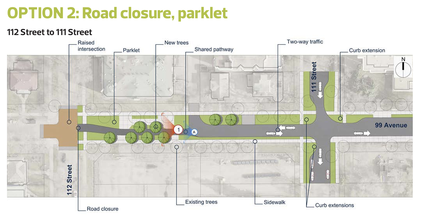
We do like the proposed roundabout at 110 St in the final design:
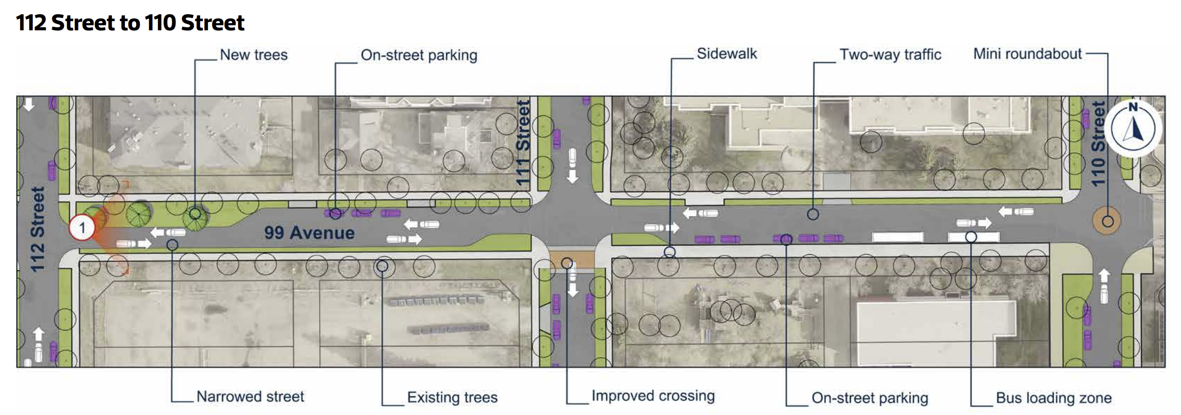
98 Ave was not included in the final design package, and the Active Transportation network map shows it as another shared street masquerading as a Local Street Bikeway:
Earlier designs included a parklet at 111 Street: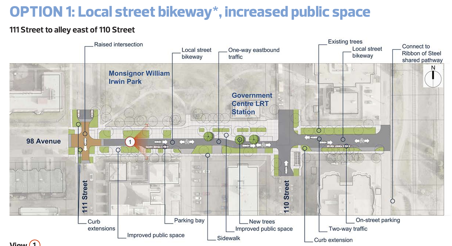
If this parklet, the roundabout, and a modal filter/parklet at 99 and 102 Ave were implemented, the safety of this area would improve dramatically.
There would still be concerns about winter maintenance, and cars circling about looking for free parking, but the area would be notably safer, more livable, and the local businesses, residents, and visitors would all benefit from the improved public space.
We would still prefer Protected Bike Lanes, at least continuing down 112 Street south of Jasper Ave, that connect to the improved High Level Bridge/Ezio Farone Park area: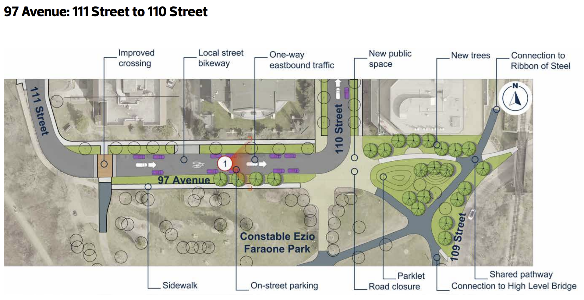
This park is easily the strongest part of this design and the team deserves a lot of credit for maintaining it. The current crossing is extremely dangerous and one of the busiest active transportation locations in the city.
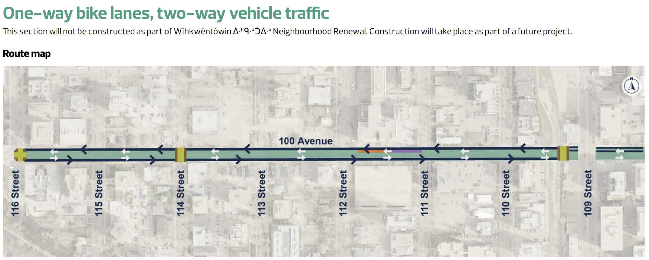
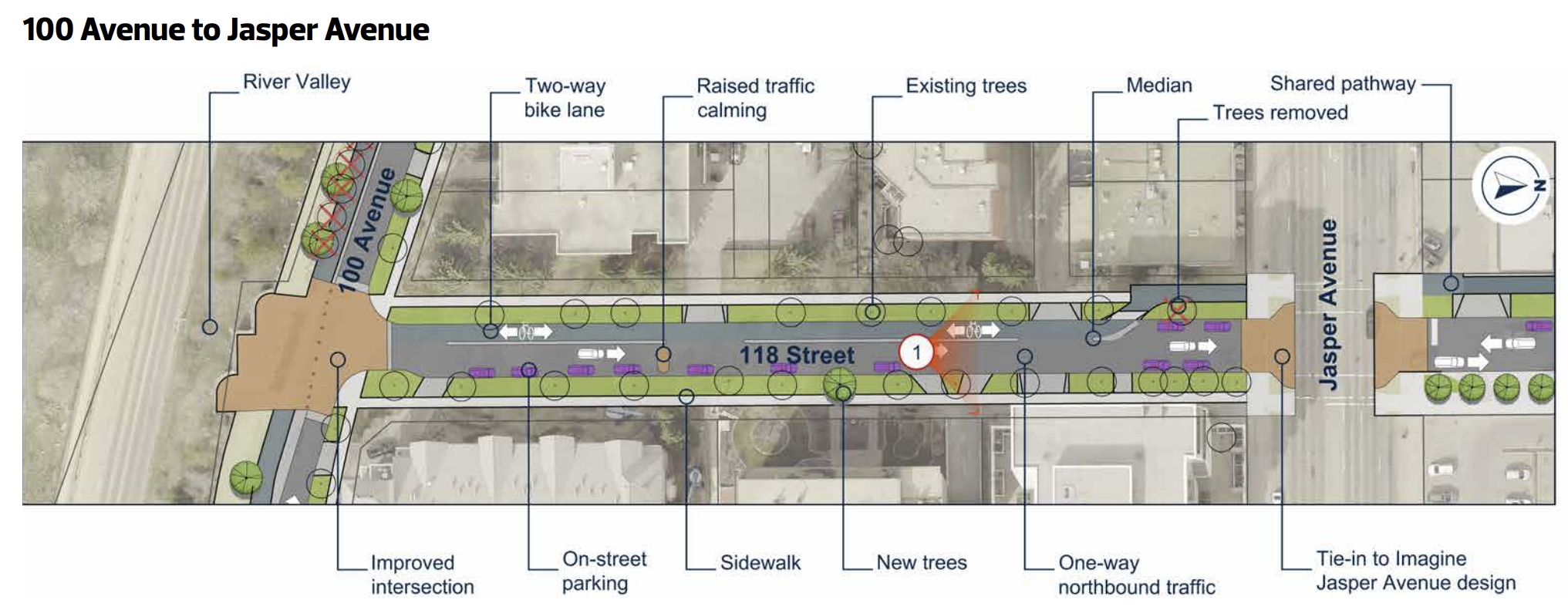
Victoria Promenade and 100 Ave
100 Ave has moved to being out of scope between 116 Street and 109 Street, so we won't focus on those designs. We understand that this will be worked on as part of an Arterial Renewal, and we believe that will include work east of 109 Street. The major concern with the design at this time is the inconsistent bike facilities. They are 2-way west of 116 Street and east of 109 Street, but 1-way in between - that's not an ideal design, especially for people on cargo bikes. However, this issue may be resolved as part of that renewal project so we won't belabour the point.
The design of the Promenade is good: a bi-directional protected bike lane. The crossing at 116 Street has been improved and we believe the design is good:
- One lane of traffic heading west on 100 Ave, going down the hill and accessing the Promenade.
- A tight right turn across a raised crossing that should allow drivers to see both pedestrians and cyclists.
- Enough space to stop between the path and the road, reducing driver stress and hopefully giving them permission to stop of people outside of cars.
We are unsure about whether this access point is required at all, and if it isn't (i.e., all residential buildings are otherwise accessible), we would prefer it be removed.
That would make this design great.
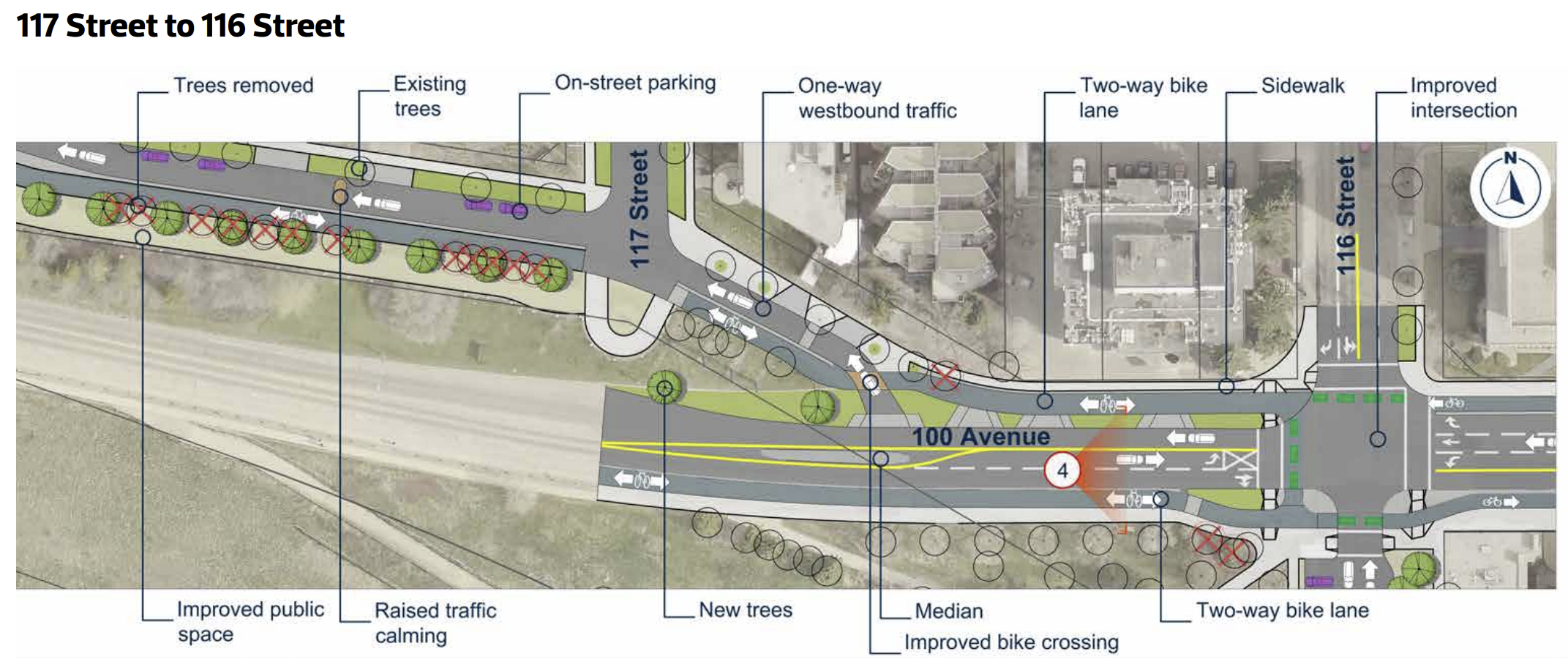
The crossing on the west side of the remains a concern:
 This bi-directional bike lane had to resolve to unidirectional bike lanes because Imagine Jasper Ave would not improve their design to align with improved safety of this design. We believe this design will force conflict at the resolution point above, and this could be mitigated with a modal filter at 118, or a closure of the east end access point onto the Promenade.
Otherwise this is a great design, and the team did well here. Some trade-offs were beyond their control, and they seem to have struck a reasonable balance, though we see potential for improvement.
102 Ave
102 Ave is effectively out of scope. There are a few small things happening, but for the most part it will remain as-is. That's a real shame. This is already the preferred route for people outside of cars, and it could be improved to further reduce conflict, making the area better for people outside of cars, without compromising driver access. Some excellent ways to prioritize safety and minimize short-cutting would include:
- Add a modal filter for westbound traffic on 102 Ave by extending the parklet to the alley west of 112 Street and add a traffic diverter for northbound cars at 102 Ave, allowing right turns only. This would reallocate space for only half a block between the alley and the proposed parklet, which would further reduce conflict at 111 and 112 Street on 102 Ave.
- Closure of 111 Street north of 102 Ave. Currently, they are proposing reducing 111 Street to southbound traffic only, and that will help reduce conflict at 102 Ave. Their proposed design would continue to allow short-cutting between 104 and Jasper Ave, and 102 Ave is a very busy intersection. Combined with our prefertreatments at 112 Street, this change would allow cars to circulate from Jasper north on 112 then back to Jasper on 111. Full access, less conflict.
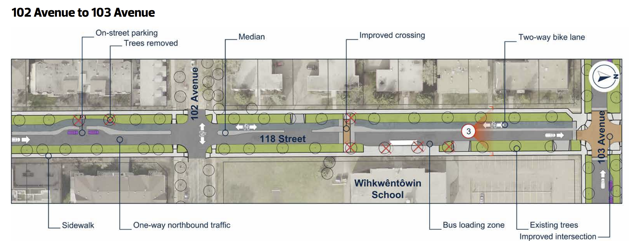
- Traffic diverter at 118 Street, sending traffic northbound. We would also like to see 118 Street be northbound traffic, and 119 to be southbound traffic, but adding a diverter at the school would further reduce short-cutting between 124 and 116 Street using 102 Ave. This would improve safety around the school, while again maintaining access for drivers. This would also prevent short-cutting between Jasper and 104 Ave along 118 Street, calming the area around the school.
- Full closure for eastbound traffic at 121 Street. Cars would still be able to access 102 Ave by using the alley behind the Oliver Exchange Building when travelling north on 121 Street from Jasper. This would prioritize the area for people outside of cars, and would enable a pedestrian plaza that ties into the businesses at Oliver Exchange. This is already a busy area of the neighbourhood, and one of the most vibrant and thriving areas in the downtown area. This is what it would mean to lean into what's already working.
- All stops signs east-west should be removed to prioritize cycling. Combined with the treatments above, this would allow 102 to move people outside of cars through the neighbourhood, allowing better access to businesses or other destinations, and improving commuting times while reducing conflicts.
We also think that 123 Street from 102 Ave to 103 Ave should be pedestrianized and dedicated as a space for the farmer's market. This would reduce conflicts on 102 Ave when the farmer's market is open, and allow ETS to maintain bus access along 102 Ave between 121 and 124 Street.
111 Street
This is generally not a key cycling route. However, there are a few important intersections that could be improved due to their interactions between cars and the larger bike network.
103 Ave
There are improvements here that we really appreciate:
- The connection to Rail Town Park is great to see
- Switching to one-way traffic helps calm traffic south of here
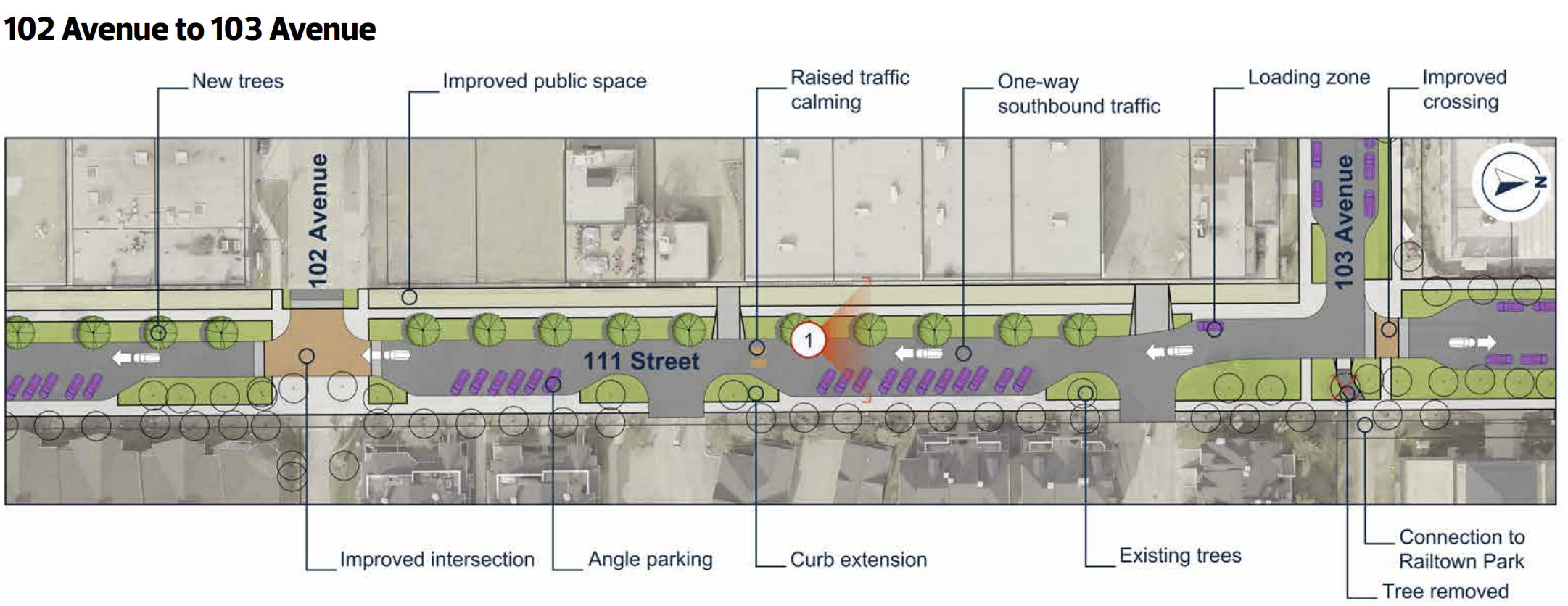
There are some key improvements that could easily be made to prioritize safety:
- Close the intersection at 102 Ave just north of the intersection. This would allow full access to the parking and driveways north of 102 Ave (and would require maintaining 2-way traffic between 102 and 103). This is already a very busy intersection with a lot of modal conflict.
- Add a traffic table at 103 Ave to slow drivers for pedestrians crossing on either side of the avenue, and to make accessing Rail Town Park safer for everyone.
112 Street
Overall, this design is quite good. The team clearly listened to many suggestions we made in this area, and we appreciate that. The connection across 104 Ave is improved, as is the connection point to the pathway beside MacEwan that connects to 105 Ave.
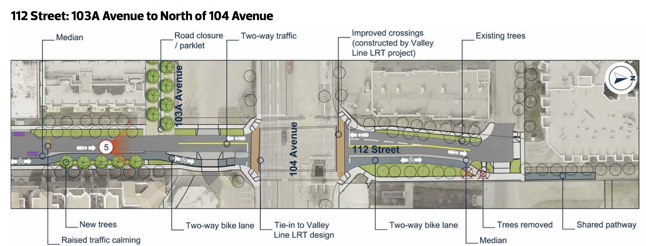
We really like the parklet as well. This is a great modal filter in an area that has a lot of shortcutting as drivers try to avoid 109 Street. This is how we prioritize safety of people outside of cars (and inside them) over the convenience of people who are not start or ending their trip in the area. We think it could be extended west along 102 Ave for half a block to act as a modal filter for westbound car traffic as well.
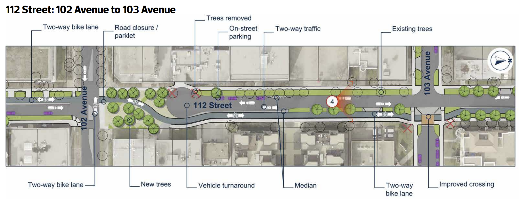
There are some proposed changes on 102 Ave at 112 Street that were previously discussed which we think would help improve this design. There are other improvements that could be made, some of which should be non-negotiables.
For example. south of 100 Ave, this route becomes a Local Street Bikeway. Of course, this isn't what a Local Street Bikeway looks like: this is just a shared street.
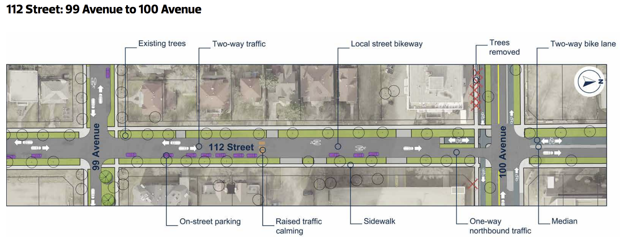
With no modal filters, no loss of parking, and no protection, this will not be a very safe route. It's still possible for cars to shortcut through here to avoid the intersection at 109 Street and 100 Ave. Thankfully, they can no longer access the High Level Bridge by driving through the neighbourhood, but plenty of drivers will continue to be able to circle the area looking for free parking.
Also, Local Street Bikeways get no winter priority clearing at all. This will be cleared as the lowest priority when the city gets around to residential roads. That's been increasingly delayed over the past several years, and would require a substantial SNIC budget increase to address. Shifting the design to Protected on Street Bike Lanes would allow low cost winter maintenance to be completed with priority 1 or 2 levels. This could even be added to the winter priority network, ensuring an Always Available route that is also All Ages and Abilities (5A - the standard we should be aiming for in the redeveloping area). Since this will be an improved access to the High Level Bridge for cyclists - one of the busiest active transportation corin the city - compromising on safety for cyclists to provide a handful of taxpayer subsidized parking spots is not an acceptable compromise.
118 Street
Along with 121 Street and 112 Street, this is the only other cycling access to Victoria Promenade, and sadly, from just north of Jasper Ave and heading south, there really isn't anything at all to like about this design.
First, the design at Jasper Ave is horrible. Shared pathways are unsafe crossings, that's precisely why sidewalk riding is illegal. This is also very difficult for SNIC to clear, so these connections will disappear or be unreliable in the winter.
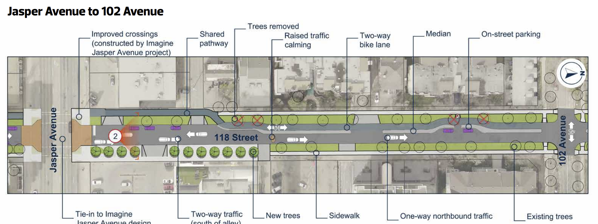
This will also create confusion for drivers. The crossing at 121 Street and Jasper Ave includes unidirectional bike lanes. The crossing at Jasper and 112 Street is a bidirectional bike lane. Here, they've gone with 'if you get hit it's your fault'. The safest desi are consistent designs; that helps drivers know what to expect. Changing the design 3 times in 9 blocks will create confusion for drivers and that will reduce safety for cyclists. This is unacceptable.
118 and Victoria Promenade is also a great location to add a traffic diverter or a parklet. Since it is already a one-way northbound, using this location to reduce traffic on the Promenade would improve safety at the awkward bidirectional to unidirectional bike lane resolution point at 121 Street south of Jasper Ave. We can't improve that design due to other projects, but we can make it safer by reducing conflict. The Promenade would need to be two-way for cars for half a block to accommodate that, or the diverter would need to be on 119 Street but both could be doable.
Having a Protected Bike Lane between Jasper Ave and 103 Ave is great to see! We're really happy with the design in this segment, though we discussed adding a traffic diverter at 102 Ave to reduce shortcutting along 118 Street and along 102 Ave. That would also help slow cyclists as the cross paths with the intersection of two bidirectional bike lanes.
We don't love the design north of 103 Ave:
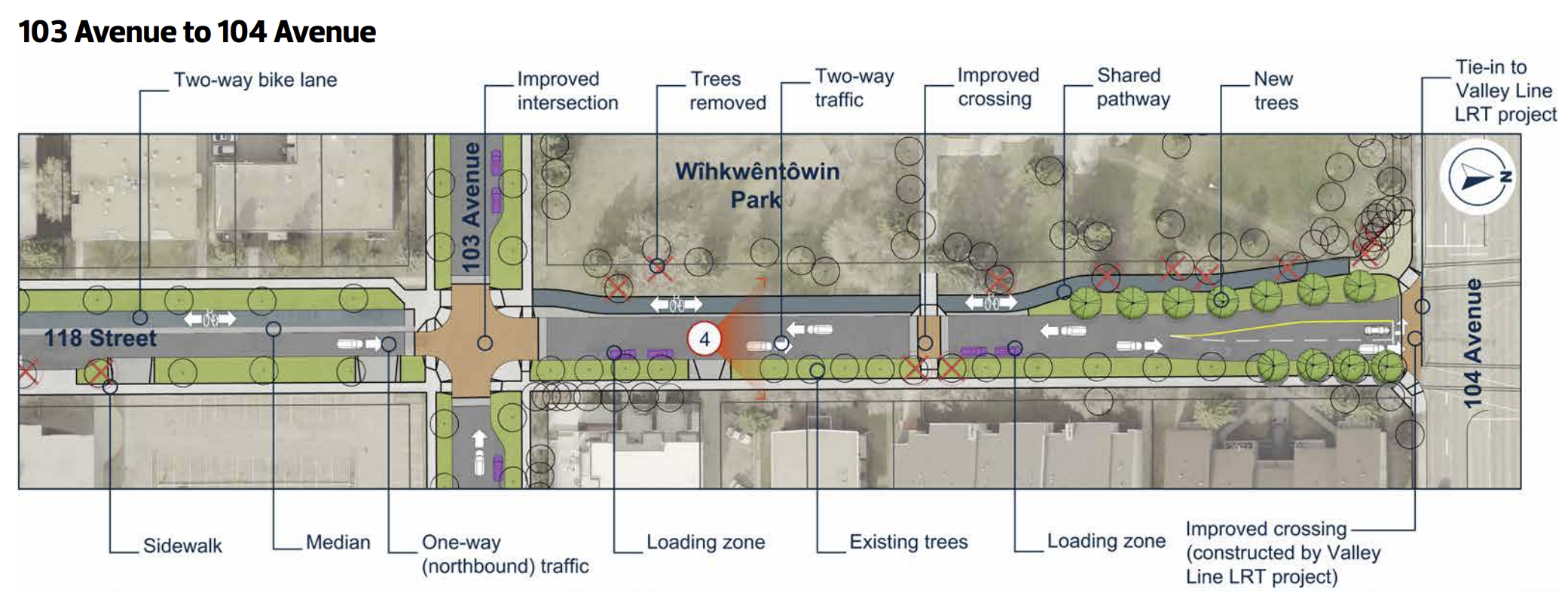
Traffic on 104 Ave will be calmed quite a bit by the LRT, but the shared path doesn't resolve heading into Unity Square. There are lights here, but no cycling infrastructure north of 104 Ave, so cyclists would need to cross the street and establish lane position, all while drivers are going into and out of the shopping area. That's recipe for conflict. The bidirectional bike lane doesn't really help either, so it would be better to use unidirectional bike lanes or a shared street. We generally don't love shared streets, but with the modal filter proposed on 103 Ave and 120 Street (we'd prefer 119 Street) and our preference for a diverter at 102 Ave and 118 Street, traffic here would be minimal, and the traffic table at 103 Ave would help slow traffic and allow resolution between the bidirectional bike lane and the shared street. The greater conflict is the 104 Ave intersection so letting cyclists establish lane position before the conflict will help keep them visible.
Of course, having a bidirectional bike lane north of 104 Ave into Unity Square would be much better, but it seems unlikely that the City would make that happen.
119 Street
This is not a bike route, but we want to summarize some of the changes we proposed elsewhere that would affect this route.
First, the traffic diverter proposed at 103 and 120 Street would be better at 119 Street, along with a change to southbound traffic at least between 102 and 104 Ave. This would reduce shortcutting, allow access to the school, while also calming the area, and reduce conflict with drivers at the bike lane along 102 Ave.
119 Street is also a potential location for a traffic diverter on Victoria Promenade to make the bidirectional to unidirectional bike lane transition near 121 Street safer.
121 Street
This is just a missed opportunity to have vision and do something great. We don't like very much about this design, and the previous options were better and still short-sighted. Preserving access between Jasper and 104 Ave on 121 Street when the arterial at 124 is only 3 blocks away is inexcusable. Building an alley so one house can continue to access their driveway, especially when it's owned by a church who pays nothing at all in taxes is fiscal mismanagement, and creating a green space that forces conflict between pedestrians and cyclists instead of using a bidirectional bike lane is just lazy planning.
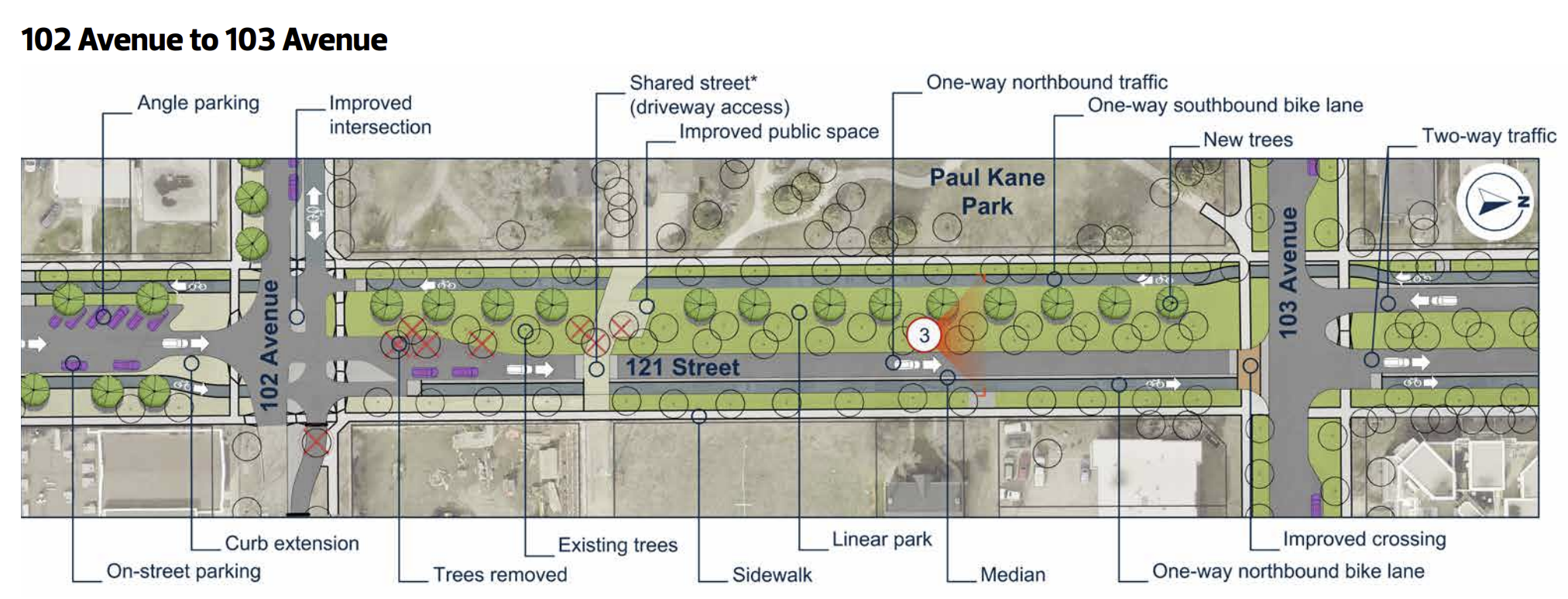
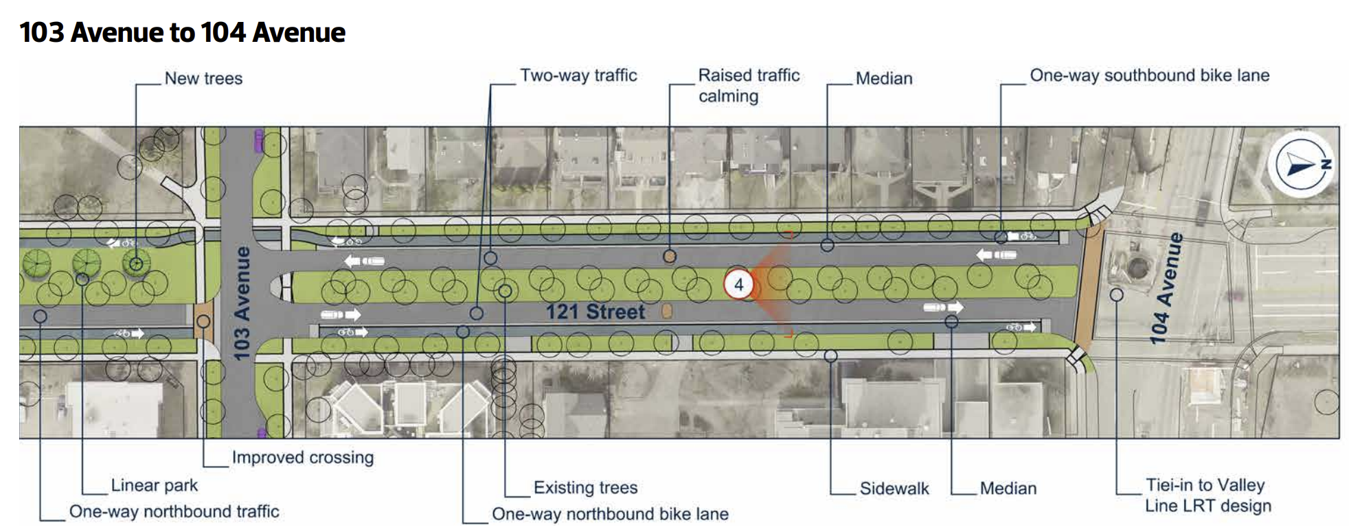
The unidirectional bike lanes could resolve back to bidirectional bike lanes between Jasper and 102 Ave. Maintaining that bidirectional bike lane all the way north to 106 Street would improve cyclist safety along a key north south c, and would improve the connection to the linear park that starts at 121 Street and 106 Ave heading north. Between 104 and 106 Ave, the 'bike lanes' are painted gutters that disappear entirely in the winter, and are usually blocked by illegally parked cars in the summer. The corner at 106 and 121 Street is a very dangerous. All of this could be dealt with by installing a bidirectional bike lane on the east side of 121 Street. 106 Ave is also a key connection to the west end, with a 'bike route' that extends all the way to Mayfield, and includes a corr that is planned to be upgraded as part of the $100M Active Transportation Network Expansion project. Not improving this connection is a huge missed opportunity, and again, bad planning.
Wrap Up
This isn’t a call to restart Wîhkwêntôwin Neighbourhood Renewal. It’s a call to finish it properly.
The City’s own policies — City Plan, Vision Zero, the Bike Plan, and winter design standards — already support safer crossings, reduced shortcutting, and continuous, protected bike infrastructure. Earlier design iterations reflected that direction, even if they had room for improvement. The final draft steps back from it.
That step back has real consequences.
Inconsistent crossings, unreliable winter routes, and car-dominated shortcuts don’t just inconvenience confident cyclists. They disproportionately harm seniors, children, people using mobility aids, and anyone for whom speed, snow, and unpredictability increase risk. A design that only works some of the year — or only for some people — is not an all-ages-and-abilities design.
There is also a clear fiscal issue. Continuing to prioritize free on-street parking in one of the most transit-rich and walkable neighbourhoods in the city is a poor use of public space and public money. The costs of collisions, enforcement, and future retrofits far outweigh the short-term political comfort of preserving parking that mainly serves people who do not live in the neighbourhood. Safe, people-first infrastructure is not just better policy — it is better asset management, and it incentivizes people to consider options other than driving, which is how we achieve City Plan and get good ROI on our big investments. Like the Valley Line West LRT project.
Wîhkwêntôwin is exactly the kind of neighbourhood Edmonton says it wants more of: dense, walkable, transit-served, and vibrant. Projects like this are rare opportunities to lock in those successes for the next 30–50 years.
Choosing parking over safety, and convenience over clarity, would be a failure of vision — not a technical necessity.
The good news is that it’s not too late. With targeted changes, this project can still become a model for how Edmonton renews its most successful neighbourhoods: by prioritizing safety, equity, and long-term value, and by trusting what already works.